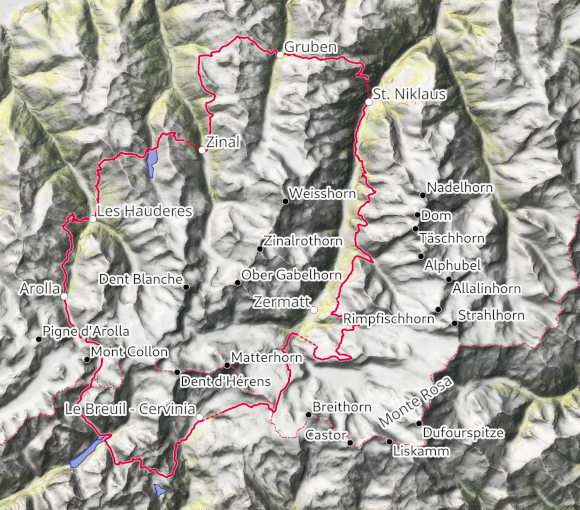
The Matterhorn is only the most famous mountain that is surrounded by this 9-day trek, and it can only be seen on about 1/3 of the route. You also hike around a number of other impressive 4000m peaks: Weisshorn, Zinalrothorn, Obergabelhorn, Dent Blanche and Dent d’Hérens. The route is flanked by Monte Rosa, Breithorn, Dom and the other peaks of the Mischabel. While you get most of the postcard views around Zermatt, I particularly like the remote and less crowded valleys along the route, such as the Turmanntal and the Col Collon and Col de Valcournera passes. It has to be said that (even according to the guide) you use cable cars several times, so the tour is not entirely on foot.
I leave the car in St. Niklaus, situated in the Mattertal valley on the road to Zermatt, and take the first cable car up to Alp Jungu early in the morning. The previous evening, I had driven through a heavy thunderstorm at walking pace, but now it looked OK: a few clouds, but a great view across the chalets up the Mattertal valley, between Mischabel and Weisshorn to the Breithorn glowing in the morning light. But the next storm was forecast for late midday, so I speeded up. A little later, I was hit by the first shower, and while I was catching my breath on the Augsbord Pass, a black wall clouds with lightnings flashing rolled over the ridge on the other side of the Turtmann Valley. I hadn’t expected it this early. I descend a little further into the valley and then set up my tent in the pouring rain and hail so that I can wait in a dry and warm place for better weather. But this comes sooner than expected and by midday I’m in the village of Gruben-Meiden in the Turtmann Valley in bright sunshine.
I climb up again on the other side of the valley, and as I pass Alp Meide, the next thunderstorm is already brewing. This time I find a good place to pitch my tent just in time.
Bright sun again in the morning. I head over the Meidpass and past the Hôtel du Weisshorn, then on a high-altitude trail high above the valley to Zinal. Unfortunately, the high peaks at the head of the valley, such as the Zinalrothorn, Obergabelhorn and Dent Blanche, are already covered in cloud again.
In Zinal, I stock up on supplies and take the cable car to Sorebois (the last one leaves at 4pm!), where I find a flat grassy spot on the edge of the ski area with view only slightly unobstructed by ski infrastructure. The mountains are covered in clouds, but I’m hoping for a nice morning. Unfortunately, the weather is not much better when I get up. I climb up to the Col de Sorebois via a ski slope and look down on the turquoise-green Lac de Moiry reservoir – until I find myself in a cloud a little later. I now descend to the dam, every now and then Dent Blanche or one of its secondary peaks can be seen in a gap in the clouds. At the lake, the sun is shining again, I cross the crest of the dam and climb up the other side to the small Lac des Autannes, which is just below the clouds that are still hanging on the ridge. Accordingly, I head over the Col de Torrent into the Val d’Hérens with little visibility. Back in the sun, the route descends across alpine meadows, then from village to village to the valley floor in Les Haudères. The valley branches off at this point, the left-hand valley leads steeply up to a glacier plateau, next to or behind which you can see Dent Blanche or Dent d’Hérens, depending on the direction of view. Arolla lies slightly higher in the other valley, with the Pigne d’Arolla (incidentally a great ski touring mountain with impressive views of the west side of the Matterhorn) and Mont Collon towering above it, on the back of which this trek leads over a pass to Italy.
To get to Arolla, the route climbs steeply from Les Haudères to the Mayens de la Couta pasture and a good bit further up, still with beautiful views. Up here I find it difficult to find a good place to bivouac, especially as a huge herd of cows comes towards me at the top on their way to be milked. Then it’s a relatively monotonous up-and-down route through sparse forest to Arolla, which I find very tiring, especially as I’m not rewarded with any views. The only exception is the pretty mountain lake Lac Blanc.
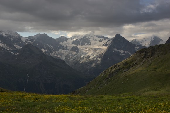
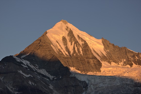
Just past Arolla, at the end of the little road, the hiking trail is closed because a bridge over a gorge cut into the moraine has been destroyed. A shock at first, because on the map this is the only way to get into the high valley (and thus towards Italy). Fortunately, there is a (laborious) alternative via the winter route. So at lunchtime, I sit opposite the ice fall next to Mont Collon and marvel at the fact that the Cabagne des Vignettes, where I once spent a stormy night, is perched on the rocky ridge next to it. In the evening, I climb over the Haut Glacier d’Arolla (which is much shorter than on the map and the photos in the guidebook and not as white either, a large number of rocks have been released from the melting ice), and scramble up the lateral moraine behind Mont Collon, where I camp with a view of the glacier.
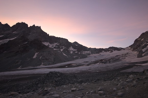
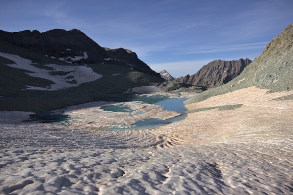
Early in the morning, I climb the last stretch to the Col Collon pass, again over a glacier coming down from the large glacier plateau. The pass is beautiful, with a meltwater lake on the Italian side with ice floes.
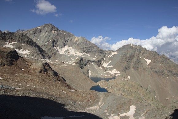
The route now descends into a mountain world characterized by rocks, to the far end of a reservoir, and up again on the other side into another high valley. From here, a sweat-inducing climb leads over two steep steps to the Col de Valcournera. On the other side, a few mountain lakes and a hut can be seen just below. I descend to the bivouac above Lac Balanselmo, where I find a good spot for my tent. It must have been an ibex’s favorite meadow, as it grazed peacefully next to my tent all evening.
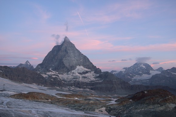
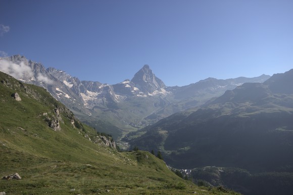
In the morning, the route continues downhill and becomes increasingly grassy. After a short ascent and another bend, I come face to face with the south face of the Matterhorn, or rather Cervinia. I walk towards this mountain peak for a while on an elevated path until I descend to the valley floor.
Unfortunately, the footpaths on both sides of the river are closed (one because of flying golf balls), but I find an alternative route above the road that takes me to the village of Breuil-Cervinia. There I wander through all sorts of small stores to stock up on provisions, the supermarket is barricaded as if it will never open again and the small stores only have a small selection. Finally, I take the cable car to Plan Maison in the ski resort, where it unfortunately looks pretty awful in summer. I hike up over the scars of winter sports (pick-ups rumble up and down the slope) and finally reach the highest point of the trek, the Theodul Pass. This is another shock, however, because the whole area around the hut is currently a huge construction site. Two excavators and other heavy machinery are digging through the rock and rebuilding the ski slope. I first ask in the hut before venturing past the prohibition sign, past the excavator (the excavator operator waves to me) and then through the mixture of mud, rock and ice chunks that the excavator has turned the slope into. Over a steep slope of rubble and ice, I reach the Theodul Glacier, over which I descend in the evening light following a ski slope.

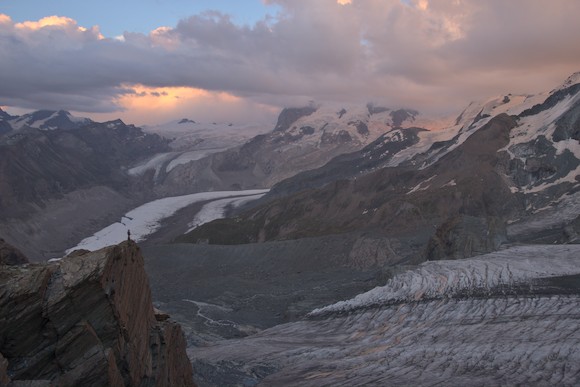
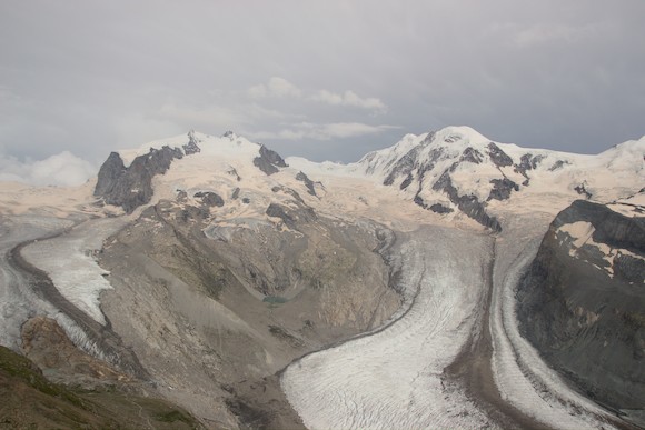
My mood improves again: the Matterhorn, stuck in a cloud, becomes dimly visible from time to time, the green humps of greenstone and serpentinite glow in the evening light (see also my book about The Formation of Mountains). And some of the other 4000-metre peaks surrounding Zermatt are almost cloudless. However, it is clear to see that the glaciers are not doing well. The last time I was in Zermatt was about 20 years ago and back then there was much more white in the landscape. I think about where I can spend the night so that I have an unobstructed view at sunrise and sunset, with as little disturbance as possible from the cable cars. In the end, I pitch my tent near the Gandegg hut directly under the cable car and am rewarded with some great photos.
Shortly after sunrise, it starts to get cloudy again, while the glaciers to the east (Cima di Jazzi) are still covered in sunspots and the cable car starts to move above me. Fortunately, the sun shines again as I descend into the valley, only the highest mountains remain shrouded. Furi, a district of Zermatt, is my lowest point today. The guide sends me along a forest path towards Grünsee, but I still want to see a bit more and take the cable car to Riffelberg to climb up the panoramic path to Gornergrad. I come across masses of tourists walking down this path…
While I was still lying in the sun and then looking down at the glacier near Riffelsee, it thunders behind me: the sky in the west has turned into a black wall and I have just enough time to put on my rain gear. Without further ado, I climb up to a nearby ski lift station and take shelter there, and once again it doesn’t take long before a patch of blue sky is visible again. Later, I’m sitting on the viewing platform on the Gornergrad, Monte Rosa and surrounding peaks are slowly peeling out of their cloud cover. The sky remains largely overcast, but the mountains glow in a strange indirect light.
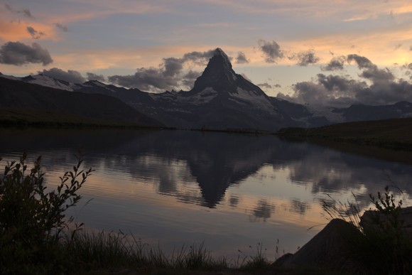
Finally, it’s down to Grünsee and up the other side to Stellisee, where I arrive just in time for sunset. It’s no secret that this is one of the best photo spots for the Matterhorn: tourists and photographers throng the shore at sunrise and sunset. And at the best spot, the water is full of algae…
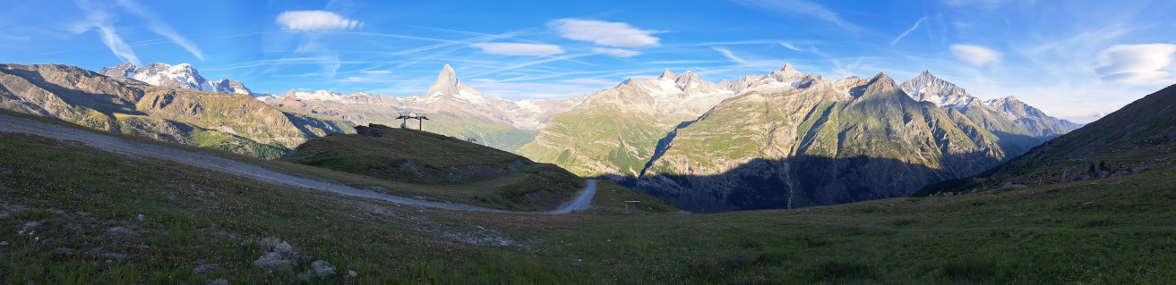
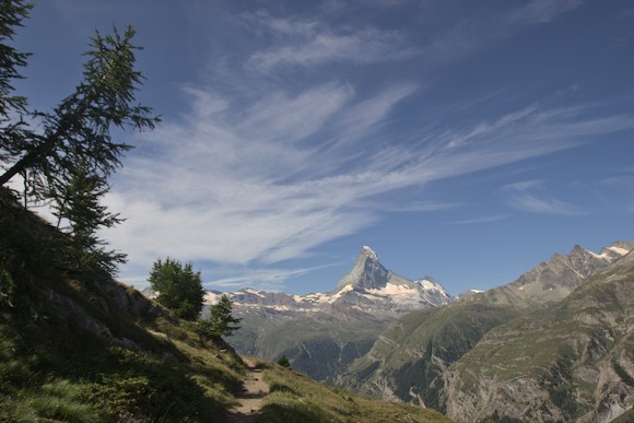
In the morning, I hike via Blauherd to Sunnega, where the Europaweg begins: this high-altitude trail forms the last two stages of the Tour Matterhorn and offers magnificent views of the Matterhorn and Weisshorn. Long stretches are so beautiful that I am so busy taking photos that progress is slow. At the Täschalm, the Dom, Täschorn and Rimpfischhorn suddenly come into view.
Crossing a rockfall-prone slope, I pass through avalanche galleries and short tunnels. The facilities have already taken a beating, the reinforced concrete of the ceiling of the galleries has crumbled from time to time and one tunnel has been filled in by a mudslide to such an extent that it is difficult to squeeze through with a rucksack.
The next but one valley cut is another rockfall slope where large boulders keep tumbling down. But you simply walk over it on the longest pedestrian suspension bridge in the world. A little later I reach the Europahütte and a little further on I find a nice place to bivouac at Miesboden.
Unfortunately, the last day is disappointing. The original Europaweg led steadily uphill from here to a panoramic mountain where the view of the Bernese Alps would open up. Then it went down to Grächen, a village above St. Niklaus. However, the route has been closed for several years and the new Europaweg leads downhill and reaches the valley floor at Herbriggen. Instead of hiking up to Grächen in the forest, I stay in the valley. It’s only 2.5 km to the car.
It was a great trek, in the same league as Tour du Mont Blanc or the Dolomites High Routes. And indeed, the Matterhorn is a special mountain. I would’t call it the most beautiful in the world, as there are more candidates (e.g. Ama Dablam, Cerro Torre, Alpamayo, Cotopaxi, Mayon), but it is one one of the most striking. And also the geology of the area is exciting. Surprisingly, I hardly met any people doing the same cirquit.